JANUARY 12, 2010 HAITI EARTHQUAKE
Latest Update:
May
1, 2015
People visiting this Web page for the first time should read the explanation section so
that they can understand the information in the line charts and the earthquake tables.
Understanding The Precursor Data On This Web Page
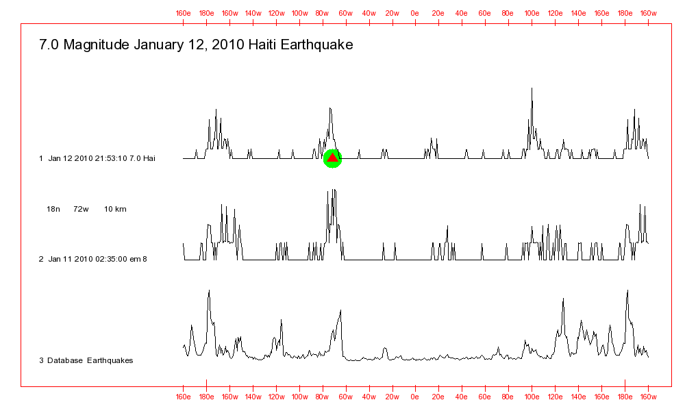
2010/01/12 21:53:10 18.45N 72.44W 10 7.0 Haiti Region
The chart below compares that January 12, 2010 Haiti Region earthquake
with the high
intensity EM Signal that was detected on January 11, 2010. That
tremendously destructive earthquake reportedly claimed the lives of a
quarter of a million people.
The EM Signal is a good match with the January 12 earthquake. And that suggests that the January 12 earthquake was triggered by the same sun and moon gravity related forces as caused the EM Signal to be generated.
The fact that there is a strong line peak at the same longitude as the earthquake indicates to me that the earthquake was probably triggered by the sun and moon gravity related forces that were responsible for the triggering of many or most of the past earthquakes that occurred at that longitude.
COMMENT - Large numbers of high intensity EM Signals were detected
during the months before that Haiti earthquake. The only one
discussed on this Web page is the one that was detected closest in time
to the earthquake.
The table below shows matches between the EM 8 signal detected on January 11, 2010 and more than 700 past earthquakes that produced at least one fatality since the start of 1973.
What is
significant is the fact that the 2nd highest probability location in the table for the destructive March 2, 1994 earthquake is
relatively close to the location where the tremendously destructive January 12, 2010 earthquake occurred.
The
data line for the actual January 12, 2010 Haiti earthquake has been
included with the table to show how the earthquake itself would appear
in the table if the analyses were done today. The location of that
earthquake would have appeared as the 3rd highest probability location.
I do
not presently have any geomagnetic energy field, gravity strength, or
thermal data for that time period. If any of those data do become available they will be added to this Web page.
Destructive Earthquakes Matches For The 2010/01/11 02:35:00 EM 8 Signal
Pa Pd Fatal Earthquake Data
84 100 6 1993/04/18 09:16:23 11.65S 76.50W 106 6.3
82 99 4 1994/03/02 03:38:03 19.80N 72.80W 59 5.4
80 96 250000 2010/01/12 21:53:10 18.45N 72.44W 10 7.0 HAITI REGION
78 93 70 1999/02/11 14:08:51 34.26N 69.30E 33 6.0
78 93 1 1987/08/13 15:23:07 17.89S 70.90W 31 6.5 southern Peru
77 92 8 1988/01/05 06:41:16 26.81S 26.64E 5 5.2 South Africa
77 92 41 1976/08/23 03:30:05
32.48N 104.18E 7 6.4 Sichuan-Gansu border region, China
76 91 7 2006/12/17
21:10:21 4.89N 95.05E 30 5.8 NORTHERN SUMATRA,
INDONESIA
75 90 12 1979/03/15 12:52:27 23.18N 101.06E 2 5.9 Yunnan, China
75 89 6 1976/05/17 02:58:43 40.38N 63.44E 15 6.7 western Uzbekistan
74 88 35 1988/08/06 00:36:26 25.09N 95.11E 90 7.3 Myanmar
73 88 1 1993/09/10 19:12:54 14.72N 92.60W 34 7.3
73 88 1 1975/10/31 08:28:04 12.54N 126.00E 51 7.5 Samar, Philippines
71 85 2 1987/12/17
02:08:19 35.41N 140.31E 49 6.5 near the east coast of Honshu,
Japan
70 84 4900 1980/11/23 18:34:54 40.79N 15.31E 6 6.9 southern Italy
68 82 33 1999/09/30 16:31:13 16.15N 96.71W 33 7.5 OAXACA, MEXICO
68 81 150 1981/01/23 21:13:49 30.94N 101.10E 5 6.5 western Sichuan, China
67 80 1 1998/03/26 16:26:11 43.26N 12.90E 10 5.6
67 80 2 1988/02/06
14:50:47 24.68N 91.52E 30 5.6 India-Bangladesh border region
65 78 2 1985/03/19 10:28:37 18.57S 63.60W 30 5.6 Santa Cruz, Bolivia
Return To Earthquake Research Homepage
The first version of this Web page was stored at this site on
April 29, 2015. Comments regarding this Web site are
welcome.
Please send them to: webmaster@earthquake-research.com
The information on this Web page represents expressions of
personal
opinion by the Web page author. The address -URL- for this Web
page is:
http://www.earthquake-research.com/archive/2010-01-12-Haiti.html